
For a PPL, CPL & ATPL aspirants who wants to become a good pilot, during flying prior to departure or enroute, earth atmosphere plays a vital role for safety of the aircraft. To ensure this, pilot has to be well versant with earth atmosphere & other topics related to aviation meteorology. At Gracious Avatar during commercial pilot training classes for PPL, CPL & ATPL aspirants, meteorology will be covered by the expert ground instructors. Atmospheric Obscurity is one of the important topics which would be covered during CPL & APTL pilot training at Gracious Avatar, Gurgaon (India).
ATMOSPHERIC OBSCURITY
Visibility
Visibility in pure air should be infinite. However, air is never pure and is laden with dust, smoke, industrial pollutants, aerosols etc. Presence of these suspended obscurities reduces the visibility.
Horizontal Visibility
Horizontal Visibility is the maximum distance along the horizontal up to which prominent objects can be seen with the naked eye and are recognized as such under natural light. Visibility may be different in different directions. The visibility reported by Met Office is the lowest Horizontal Visibility. During day Visibility is estimated by seeing objects at pre-measured distances, within and around the airfield. During night existing lights in and around the airfield at known distances are used. These are called Visibility Land Marks.
Runway Visual Range (RVR)
It is the distance up to which the pilot can see from the cockpit along the runway. RVR is reported when the visibility is less than 1500m. RVR is reported in multiples of 25M when between 50M & 150M, in multiples of 50M when between 150 & 800M, in multiples of 100M when between 800 & 1200M, and in multiples of 200M when more than 1200M.
PoorVisibility Phenomena
1.
Haze:
Atmospheric obscurity due to very small particles of smoke, dust, water etc.,
wherein the visibility reduces to 5000M or less (but more than 2000M) is termed
as haze. When the Relative Humidity is 75% or more, this is termed as Moist Haze(or
simply Haze) whilst if the RH is less than 75% it is termed as Dust Haze or
smoke Haze.It gives a milky appearance to the sky.
2.
Dust Haze: Atmospheric
obscurity due to dust particles in suspension with RH less than 75% reducing
visibility to 500oM or less is termed as Dust haze. It is caused by the strong
winds in the desert or arid areas arising due to a steep pressure gradient
kicking up dust in the stable lower layers of the atmosphere.
3. Smoke
Haze: Atmospheric
Obscurity due to suspended smoke from industrial or domestic sources reducing
visibility to 5000M or less is termed as Smoke haze. Smoke Haze occurs when
wind is calm and there is strong ground inversion.
4.
Mist:
Atmospheric obscurity due to suspended droplets wherein visibility reduces to 1000
M to less than 2000 M, with RH being 75% or more.
5.
Fog: Atmospheric
obscurity due minute water droplets suspended in the air reducing visibility to
less than 1000M.In Fog RH is nearly 100%. Fog may be termed as thick, moderate
or light depending upon visibility.
6.
Smog: When smoke
haze & fog co-exist, it is called Smog. In smoke visibility is very poor.
7.
Dust Storm:
The visibility in dust storm is 5000M or less. If the dust storm is followed by
rain visibility improves fast.
8.
Precipitation:
The visibility in precipitation depends on the size of the drop and intensity
of precipitation. In moderate Rain vis may reduce to 1-3 km, in heavy Rain or
showers to less than 1000M, in drizzle to 3 km and in snowfall it may reduce to
less than 1000M.
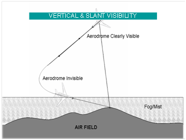
Horizontal, Vertical & Slant Visibility
1. Visibility reported by Met Office is minimum horizontal
vis.
2.
Vertical visibility
may be much better during shallow fog as it is the distance up to which one can
see objects along the vertical.
3.
Slant visibility is the
visibility at an angle and can be defined as the distance an object can be seen
along the path that is at an an angle to the horizontal( usually glide path or
landing path).In shallow fog this visibility is more than horizontal vis but
less than vertical vis.
Instrumentsfor Measuring Visibility
1.
Scopograph or
transmissometer are used for measuring vis along the different runways on an
aerodrome. RVR equipment are installed along various runways to measure RVR.
2.
Close to take off
& landing areas.
3.
The equipment
consists of a light source and a photo-electric receiver, which generates
electric current according to the obscurities present between the transmitter
and receiver. The current so generated gives a measure of RVR. The display
units are installed in Met Office and ATC Tower.
Fog
1.
Fog is composed of
tiny water drops or ice crystals. It is nothing but a stratus cloud sitting
smack on the ground. Fog occurs due to condensation of water vapour present in
the layers of air close to the ground. Condensation can occur either by cooling
of the air close to the ground or by feeding moisture in to the air to saturate
it. Fog can be various types:
2.
Radiation Fog:
Radiation Fog forms due to nocturnal cooling of the ground and the adjacent
layers. The conditions favorable for formation of Radiation Fog are:
a.
Clear skies
b.
High relative
Humidity e.g. after Rain
c.
Light freshening wind of 3 to 8 kt
3. Radiation fog is most frequent at about sunrise and
dissipates within 2-3 hours after sunrise due to heating. If the Fog is thick
it may take longer to lift. Generally fog lifts in to low stratus clouds before
dissipating. Radiation Fog in India occurs mostly during winters after the
passage of active western disturbances. It is almost a daily feature in winter season
in the Valley of Brahmaputra River where adequate moisture is present and
katabatic flow provides the required degree of turbulence and extra cooling.
The most susceptible areas for radiation fog are NW India, UP, Bihar, Bengal
and Assam (particularly south of Brahmaputra River).
4.
Vertically radiation
Fog extends to only a few hundred feet whilst sometimes it can extend up to
about 1500ft.
5.
Advection Fog:
Advection Fog forms when warm moist air from elsewhere is transported over the
cold surface (ground or water) where the surface temperature is less than the
dew point of the advected air. Advection Fog forms both over land & sea.
Coastal fogs over Bengal and Orissa during winters are due to a combined effect
of advection from sea and radiation cooling. The Brahmaputra valley, the
coastal areas and hills of Indian Peninsula experience advection Fog.
6.
Frontal Fog: Frontal
Fog forms near the front due to saturation of air in the area of continuous
rain ahead of the front. It also forms due to lowering of the cloud to the
surface with the passage of a front.
7.
Steaming Fog: This
type of Fog is common in higher latitudes when cold air mass flows over a warm
sea surface. The water vapour from warm sea when comes in contact with the cold
air aloft condenses to form steaming fog. It is common over frozen land, ice covered
Polar Regions and over Icelandic and Norwegian regions. Over sea it is often
referred to as sea smoke. It looks like steam coming out of the surface.
Fog Dispersal:
1.
Thermal Dispersion:
When air is heated to temperatures above dew point, fog or cloud will
dissipate.
2.
Dispersal using Hygroscopic Nuclei: When hygroscopic particles are injected into fog water
drops form. This lowers the relative humidity of the air and fog dissipates.
For More Info :- https://www.graciousavatar.in/Pilot-Training/CPL.php
