For a PPL, CPL & ATPL aspirants who wants to become a good pilot, during
flying prior to departure or enroute, earth atmosphere plays a vital role for
safety of the aircraft. To ensure this,
pilot has to be well versant with earth atmosphere & other topics related
to aviation meteorology. At Gracious
Avatar during commercial pilot training classes for PPL, CPL & ATPL
aspirants, meteorology will be covered by the expert ground instructors. Winds
is one of the important topics which would be covered under meteorology subject
during CPL & APTL pilot training at Gracious Avatar, Gurgaon (India).
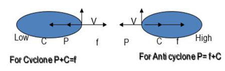
1. If the wind is blowing along
curved isobars of radius r with a velocity V it has an acceleration towards the
centre, called centripetal force (V2/r). The centripetal force(C)
acting on a unit volume of air=ρV2/r. If the Coriolis force is
negligible as compared to the forces P & C, then
ρV2/r=P therefore V= (Pr/ ρ)1/2 . Such a motion
is called cyclostrophic. Near the centre of a tropical revolving storm or in a
circular tornado, the equation gives a good approximation to the actual wind.
2. Cyclostrophic wind is defined
as wind that blows as a result of balance between PG Force & Cyclostrophic
Force.
Gradient
Wind
It is the wind that blows
parallel to the curved isobars under the balance of Pr Grad Force, Coriolis
Force & Centripetal Force. In mid latitudes this wind is closer
approximation than geostrophic wind.
Isallobaric Wind
When the pressure
changes rapidly, the geostrophic and gradient rules do not apply. In such a
case another force called isallobaric force comes into play. This force is
directed from higher isallobar to lower isallobar. This deflects the wind
towards the falling pressure. The wind under the influence of P, f and
isallobaric force is called the Isallobaric wind.
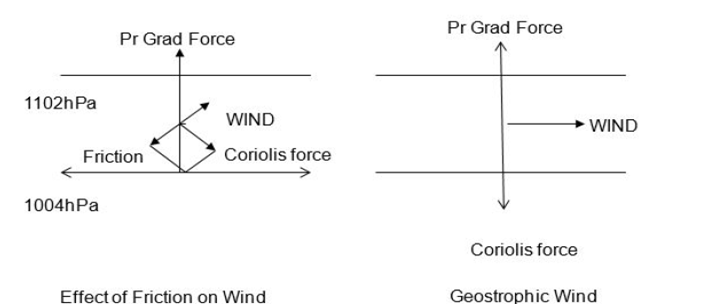
Effect of Surface Friction
The rough terrain causes friction. Depending upon wind speed, lapse rate and roughness of the surface, effect of friction may extend to about 1 km. This layer is called friction layer. Thickness of the layer is variable. Within the friction layer wind slows down and the Coriolis force reduces proportionately and is insufficient to balance Pressure Gradient Force. The wind is therefore, deflected towards the low pressure and the flow become cross isobaric.
As a rough rule, over sea where friction is small, surface wind blows at about 15o to isobars. Over land it is 30o to the isobars with its speed about 1/3 to 1/2 of geostrophic value.
For a PPL, CPL & ATPL aspirants who wants to become a good pilot, during
flying prior to departure or enroute, earth atmosphere plays a vital role for
safety of the aircraft. To ensure this,
pilot has to be well versant with earth atmosphere & other topics related
to aviation meteorology. At Gracious
Avatar during commercial pilot training classes for PPL, CPL & ATPL
aspirants, meteorology will be covered by the expert ground instructors. Atmospheric
Obscurity is one of the important topics which would be covered during CPL &
APTL pilot training at Gracious Avatar, Gurgaon (India).
Visibility in pure air should be infinite.
However, air is never pure and is laden with dust, smoke, industrial
pollutants, aerosols etc. Presence of these suspended obscurities reduces the
visibility.
Horizontal Visibility is the maximum distance
along the horizontal up to which prominent objects can be seen with the naked
eye and are recognized as such under natural light. Visibility may be different
in different directions. The visibility reported by Met Office is the lowest
Horizontal Visibility. During day Visibility is estimated by seeing objects at
pre-measured distances, within and around the airfield. During night existing
lights in and around the airfield at known distances are used. These are called
Visibility Land Marks.
It is the distance up to which the pilot can
see from the cockpit along the runway. RVR is reported when the visibility is
less than 1500m. RVR is reported in multiples of 25M when between 50M &
150M, in multiples of 50M when between 150 & 800M, in multiples of 100M
when between 800 & 1200M, and in multiples of 200M when more than 1200M.
1.
Haze:
Atmospheric obscurity due to very small particles of smoke, dust, water etc.,
wherein the visibility reduces to 5000M or less (but more than 2000M) is termed
as haze. When the Relative Humidity is 75% or more, this is termed as Moist Haze(or
simply Haze) whilst if the RH is less than 75% it is termed as Dust Haze or
smoke Haze.It gives a milky appearance to the sky.
2.
Dust Haze: Atmospheric
obscurity due to dust particles in suspension with RH less than 75% reducing
visibility to 500oM or less is termed as Dust haze. It is caused by the strong
winds in the desert or arid areas arising due to a steep pressure gradient
kicking up dust in the stable lower layers of the atmosphere.
3. Smoke
Haze: Atmospheric
Obscurity due to suspended smoke from industrial or domestic sources reducing
visibility to 5000M or less is termed as Smoke haze. Smoke Haze occurs when
wind is calm and there is strong ground inversion.
4.
Mist:
Atmospheric obscurity due to suspended droplets wherein visibility reduces to 1000
M to less than 2000 M, with RH being 75% or more.
5.
Fog: Atmospheric
obscurity due minute water droplets suspended in the air reducing visibility to
less than 1000M.In Fog RH is nearly 100%. Fog may be termed as thick, moderate
or light depending upon visibility.
6.
Smog: When smoke
haze & fog co-exist, it is called Smog. In smoke visibility is very poor.
7.
Dust Storm:
The visibility in dust storm is 5000M or less. If the dust storm is followed by
rain visibility improves fast.
8.
Precipitation:
The visibility in precipitation depends on the size of the drop and intensity
of precipitation. In moderate Rain vis may reduce to 1-3 km, in heavy Rain or
showers to less than 1000M, in drizzle to 3 km and in snowfall it may reduce to
less than 1000M.
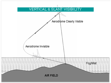
1. Visibility reported by Met Office is minimum horizontal
vis.
2.
Vertical visibility
may be much better during shallow fog as it is the distance up to which one can
see objects along the vertical.
3.
Slant visibility is the
visibility at an angle and can be defined as the distance an object can be seen
along the path that is at an an angle to the horizontal( usually glide path or
landing path).In shallow fog this visibility is more than horizontal vis but
less than vertical vis.
1.
Scopograph or
transmissometer are used for measuring vis along the different runways on an
aerodrome. RVR equipment are installed along various runways to measure RVR.
2.
Close to take off
& landing areas.
3.
The equipment
consists of a light source and a photo-electric receiver, which generates
electric current according to the obscurities present between the transmitter
and receiver. The current so generated gives a measure of RVR. The display
units are installed in Met Office and ATC Tower.
1.
Fog is composed of
tiny water drops or ice crystals. It is nothing but a stratus cloud sitting
smack on the ground. Fog occurs due to condensation of water vapour present in
the layers of air close to the ground. Condensation can occur either by cooling
of the air close to the ground or by feeding moisture in to the air to saturate
it. Fog can be various types:
2.
Radiation Fog:
Radiation Fog forms due to nocturnal cooling of the ground and the adjacent
layers. The conditions favorable for formation of Radiation Fog are:
a.
Clear skies
b.
High relative
Humidity e.g. after Rain
c.
Light freshening wind of 3 to 8 kt
3. Radiation fog is most frequent at about sunrise and
dissipates within 2-3 hours after sunrise due to heating. If the Fog is thick
it may take longer to lift. Generally fog lifts in to low stratus clouds before
dissipating. Radiation Fog in India occurs mostly during winters after the
passage of active western disturbances. It is almost a daily feature in winter season
in the Valley of Brahmaputra River where adequate moisture is present and
katabatic flow provides the required degree of turbulence and extra cooling.
The most susceptible areas for radiation fog are NW India, UP, Bihar, Bengal
and Assam (particularly south of Brahmaputra River).
4.
Vertically radiation
Fog extends to only a few hundred feet whilst sometimes it can extend up to
about 1500ft.
5.
Advection Fog:
Advection Fog forms when warm moist air from elsewhere is transported over the
cold surface (ground or water) where the surface temperature is less than the
dew point of the advected air. Advection Fog forms both over land & sea.
Coastal fogs over Bengal and Orissa during winters are due to a combined effect
of advection from sea and radiation cooling. The Brahmaputra valley, the
coastal areas and hills of Indian Peninsula experience advection Fog.
6.
Frontal Fog: Frontal
Fog forms near the front due to saturation of air in the area of continuous
rain ahead of the front. It also forms due to lowering of the cloud to the
surface with the passage of a front.
7.
Steaming Fog: This
type of Fog is common in higher latitudes when cold air mass flows over a warm
sea surface. The water vapour from warm sea when comes in contact with the cold
air aloft condenses to form steaming fog. It is common over frozen land, ice covered
Polar Regions and over Icelandic and Norwegian regions. Over sea it is often
referred to as sea smoke. It looks like steam coming out of the surface.
1.
Thermal Dispersion:
When air is heated to temperatures above dew point, fog or cloud will
dissipate.
2.
Dispersal using Hygroscopic Nuclei: When hygroscopic particles are injected into fog water
drops form. This lowers the relative humidity of the air and fog dissipates.
For More Info :- https://www.graciousavatar.in/Pilot-Training/CPL.php
For a PPL, CPL & ATPL aspirants who wants to become a good pilot, during flying prior to departure or enroute, earth atmosphere plays a vital role for safety of the aircraft. To ensure this, pilot has to be well versant with earth atmosphere & other topics related to aviation meteorology. At Gracious Avatar during commercial pilot training classes for PPL, CPL & ATPL aspirants, meteorology will be covered by the expert ground instructors. Humidity is one of the important topics which would be covered during CPL pilot training.
Water vapor is always present
in the air to a greater or lesser extent, in the troposphere.
Water evaporates into the air
from oceans, lakes, vegetation etc. It ascends and forms clouds which cause
precipitation.
Water exists in three phases:
the gas (water vapor), liquid (rain, drizzle, shower) and solid(snow, hail).
The capacity of air to hold
water vapor depends largely on temperature and to some extent on pressure.
Higher the temperature, higher is the capacity of air to hold water vapor.
Dry Air:
Air that contains no water vapor. Exists in upper troposphere or stratosphere.
Moist Air:
The normal air that we breathe. It is also called unsaturated air.
Saturated Air: When air holds maximum
water vapor, it is called saturated air.
Vapor Pressure:
The partial pressure exerted by water vapor in the air. If p is the total
pressure of air and e is the vapor pressure, then p-e is the pressure of dry
air.
Saturated Vapor Pressure:
It is the pressure exerted by water vapor when air is saturated.
Absolute Humidity:
It is the actual amount of water vapor contained in a given volume of air at a
given temperature. It is expressed as g/m3.
Humidity Mixing Ratio: It is defined as the mass
of water vapor contained in a given mass of air. It is expressed as g/kg.
Humidity Mixing Ratio for Saturated Air: It is defined as the maximum mass of water vapor that can be contained in a given mass of air at a particular temp and pressure. It is expressed as g/kg.
Relative Humidity: It is defined as the ratio,
in percentage, of the actual water vapor present in the air to the maximum it
can hold at the same temperature and pressure.
RH= HMRx100/HMR for saturated
air.
RH=Vapor pressure of
Airx100/Saturation vapour pressure of Air.
Wet Bulb Temperature (Tw
Tw): It is the lowest temperature which air would attain by
evaporating water into it to saturate it. Desert Coolers work on this
principle.
Dew Point Temperature (Td Td):
It is the lowest temperature to which air should be cooled at constant pressure
to saturate it with respect to water. Cooling below dew point causes
condensation.
Frost Point: It is the
temperature to which air must be cooled to reach saturation with respect to
ice. Cooling below the frost point causes formation of hoar frost.
As the temperature of the air
increases, the amount of water vapour required to saturate it also increases.
At subzero temperatures water
molecules have more energy and greater degree of freedom than ice, consequently
the saturation vapour pressure over water drops is more than that over ice
particles.
If water drops and ice
particles co-exist, water drops will evaporate and condense on the ice
particles. This explains rainfall from clouds which extend above 0oC
and have both super cooled water drops and ice crystals co-existing.
Small water drops can exist
in super cooled state up to -40o C.
For saturated Air( in Fog,
Rain ) Air Temp(TT)=TwTw=TdTd
For unsaturated air: Dry Bulb Temp>Wet Bulb Temp>Dew Point
For a PPL, CPL & ATPL aspirants who wants to become a good pilot, during flying prior to departure or enroute, earth atmosphere plays a vital role for safety of the aircraft. To ensure this, pilot has to be well versant with earth atmosphere & other topics related to aviation meteorology. At Gracious Avatar during commercial pilot training classes for PPL, CPL & ATPL aspirants, meteorology will be covered by the expert ground instructors. Temperature is one of the important topics which would be covered during CPL pilot training.
It is measured by
means of thermometer in degrees Celsius or Fahrenheit. These scales are
arbitrarily fixed with reference to the melting point of ice and the boiling point
of pure water at normal pressure. On the Celsius scale these are respectively
as 0⁰ C and 100⁰ C and in Fahrenheit scale as 32⁰ F and 212⁰ F. Celsius scale
is used internationally, in aviation and science. Use of Fahrenheit scale is
confined to English- speaking countries only.
Heat is a form of
energy. As heat is extracted from a substance, its internal energy is reduced
and the random motion of its molecules slows down. The molecules get arranged
in a more orderly pattern than before. As more heat is extracted the cooling
and orderliness increases. Finally a state is reached when no more heat can be
extracted and the molecules reach their maximum orderliness and the molecular
motion almost ceases. The lowest temperature is reached. This minimum temperature
is the same for all substances, and is accordingly called the absolute zero
(K). 1K=-273.16 ⁰ C.
Dry Bulb
Thermometer, Wet Bulb Thermometer (the bulb is covered with a muslin cloth
which is kept moist), Maximum Thermometer (like doctors Thermometer), Minimum
Thermometer and Thermograph, are used for measuring temperature.
Mercury is used in
thermometers except in Minimum Thermometer in which alcohol is used instead of
mercury.
In Thermographs and
in Upper Air temperature measurement, bi- metallic strips are used.
A minimum
thermometer has dumbbell shaped iron index, which permits alcohol to pass
through it when the temperature rises. When temperature falls the alcohol,
which has a conclave meniscus, drags the index back to indicate minimum
temperature.
Surface temperature
is recorded at a height of 4 ft(1.25m) from the ground in shade(inside a
Stevenson’s Screen).
Air which has no
water vapour content is called dry air. Such air may exist at very high levels.
For all practical purposes unsaturated air is called dry air.
With water vapour
<4 % (RH <100%) air is called unsaturated or dry.
With water vapour
>4 %(RH 100%) air is called saturated air.
Heat & Temperature
Specific Heat: It is defined as
the heat required to raise the temperature of unit mass of a substance by 1⁰C.
The specific heat of water, regarded as the highest is 1, that of ice 0.5 and
of soil 0.2.
Latent Heat: It is defined as
the amount of heat absorbed or released during change of phase from/to
solid/liquid/vapour. It is absorbed during change from solid to liquid and
liquid to gas and released during change of phase from vapour to liquid and
liquid to solid.
When water changes
to vapour, a certain quantity of heat is supplied. To change boiling water into
vapour, more than five times as much heat is required as is needed to bring the
temperature of ice cold water to a boil. Once the boiling begins, the
temperature remains constant and the heat released is stored as latent heat. It
is released as latent heat when the water vapour condenses to water.
Heat is transferred
from one place to the other by conduction, convection and radiation.
Conduction: In this
Process heat is physically transferred by the molecules by contact. Conduction
is important process of heat transfer very close to the ground.
Convection: In this
process heat is bodily transferred to the colder part of the fluid. As more
than 70% of the earth is covered with water, hence the importance of
convection. In the atmosphere free
Convection is triggered by intense solar heating and the forced Convection by
topography.
Radiation: Everybody
radiates heat at its temperature. In this process of heat transfer the medium
is neither affected nor required. The solar radiation directly heats up the
earth without affecting the atmosphere.
Other Methods:
Advection, Latent Heat release, Turbulence, Up and downward motion of air are
the other methods of heat transfer.
Diurnal variation of
temperature is more over land areas than over sea/coastal areas.
Sea Surface
temperature shows an average variation from day to night of less than 1⁰C,
whereas over land the variation may average as much as 20⁰C.
Variation is max
when wind is calm.
Due to nocturnal
cooling the surface temperature continues to fall even after sunrise till a
balance is reached between the incoming and outgoing radiation. The balance
occurs a little after sunrise.
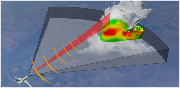
It is very interesting to know that nowadays
majority of aircraft’s fly a high altitude. But there are lots of clouding
too, in such high altitudes. So, how the aircraft manages to avoid or
penetrate such clouds. Here it is how.
Nowadays almost all the commercial aircraft are
fitted with Airborne Weather Radar
system.
It is basically a Primary Radar whose antenna is
fitted on the nose of aircraft and scans the forward area ahead of aircraft
track.
Weather Radar transmits pulses which are
reflected by the water droplets which are present on the clouds. The denser
the cloud, more will be the content of water droplets and hence more of the
transmitted pulses will be reflected back to the aircraft and the intensity
of reflected pulses will be displayed accordingly.
You will study further in details during CPL & ATPL training modules.
Finding the way from one place to another is called NAVIGATION.
Aircraft Navigation is the art and science of getting from a departure point to a destination in the least possible time without losing your way.
In
the past, plotting on the paper or on the map a course towards a
specific area of the earth used to be a task assigned to a specialized
member of the aircraft’s crew
such a navigator. Such a task was quite complicated and not always
accurate. Since it depended on the observation, using simple maps and
geometrical instruments for calculations.
Today, aerial
navigation has become an art which nears to perfection. Both external
Navaids (Navigational Aids) and on-board systems help navigate any
aircraft over thousands of miles with such accuracy that could only be
imagined a few decades ago.
Pilots have various navigation aids that help them take-off, fly, and land safely.
One of the most important aids is a series of air route traffic control, operated throughout the world.
Most
of the traffic control uses a radar screen to make sure all the planes
in its vicinity are flying in their assigned airways.
Airliners carry a special type of radar receiver and transmitter called a transponder.
It receives a radar signal from control center and immediately bounces it back.
When the signal got to the ground, it makes the plane show up on the radar screen.
There are various navigational aid equipment and system which you will study further in details during pilot training modules.